Wednesday, December 1, 2010
Infill Housing Development Perspectives
This is an excellent perspective illustrating the view of the waterfeature as seen when being viewed from the north end of the courtyard. This was probably the most influential drawing in the design packet.
This is a good perspective to illustrate the design intent for the public art piece, located on the corner of Scales and Whitfield Streets. After reviewing this drawing, I realize that an element is missing to create an overhead plane, which would make the space feel more intimate. This is a major intersection on the site, so more movable seating should have been designed into this space as well. Overall, I was pleased with all perspectives and other drawings used to support the Infill Housing Development Design Solution for Graduate Studio III, at Mississippi State University.
Infill Housing Development Perspectives
This is a very nice perspective illustrating the recessed stormwater detention facility, located within the courtyard of the single family attached housing units, located in the southeast corner of the site. After reviewing this drawing, I believe this space has been designed to attract people, and therefore promote a strong sense of community.
The purpose of this perspective was to show how the parking for the single family detached housing units was resolved through the design. As seen here, each unit has two paved spaces and one overflow space with a grasspave surface, instead of the paving. This design feature helps break up the monotony of a continuous parking lot while maintaining the benefits of a larger, box style parking lot design.
The purpose of this perspective was to show how the parking for the single family detached housing units was resolved through the design. As seen here, each unit has two paved spaces and one overflow space with a grasspave surface, instead of the paving. This design feature helps break up the monotony of a continuous parking lot while maintaining the benefits of a larger, box style parking lot design.
Infill Housing Development Perspectives
This perspective does a nice job portraying the feeling one would have while standing on the southeast corner of the large play area, located on the north end of the site. I believe this perspective is a strong selling point to this design.
This perspective is not very effective for selling the design, but to be honest, I was rapidly approaching the project deadline and needed ten perspectives. This perspective illustrates how the different elements used to create a strong and healthy pedestrian experience come together in a manner that follows the overall design concept
Infill Housing Development Perspectives
I feel as though this is an effective perspective, but I accidentally drew a vehicle exiting this area. This was a mistake on my part because this street is designed for one-way traffic only, entering from Whitfield Street.
The purpose of this perspective was to illustrate the features creating the environment in the back alley.
Infill Housing Development Perspectives
I feel as though this birds-eye view does a wonderful job illustrating the feel and character of the single family detached housing units
This perspective was very effective in illustrating how the pedestrian crosswalk would be viewed when being approached from the north. It also does a fantastic job illustrating how the trees, planted for the alley effect, would create a very formal central common green.
Details for the Infill Housing Development Project
The following details were used to describe certain features of the design in more detail. Below are three of the details prepared to support the enlarged plan.
The feature addressed by the public art detail is located on the southwest corner of the site, at the corner of Scales and Whitfield Streets. The flow-through planter detail illustrates the planter section between the bike lane and Whitfield Street.
The paver detail is illustrating the pedestrian crosswalk, 45 degree parking stalls, and the one-way driving lane. I believe each of these details was very effective in illustrating the design intent for the corresponding feature.
Enlarged Plan for the Infill Housing Development Project
As part of this project, I had to chose a section of my design to illustrate a detail plan. I chose to detail the mixed-use area, located on the southwest corner of the site.
Overall, I was pleased with the product of this phase of the project. After reviewing the plan, there are a few things I wish would have been done differently:
1. Increase the building setbacks to 10 feet, instead of 5.
2. Reconfigure some of the balcony spaces.
3. Provide a greater amount of gathering space within the interior of the courtyard (smaller waterfeature, increased gathering space).
Planting Plan for the Infill Housing Development Project
All raised flow-through planters are planted with a grass/sedge mix. The look of the grasses coming from the planters resembles the old well, which was existing on site but removed in the design. In this manner, the design retains the spirit and feeling of the old water well in a manner which is uniform throughout the entire site. All other plant materials were chosen due to their aesthetic appeal because of texture contrasts, others were chosen to ensure different flower and leaf color alterations throughout the year. Plant materials have also been used throughout the design to define space. Overall, I was pleased with the planting design scheme.
Sections for the Infill Housing Development Project
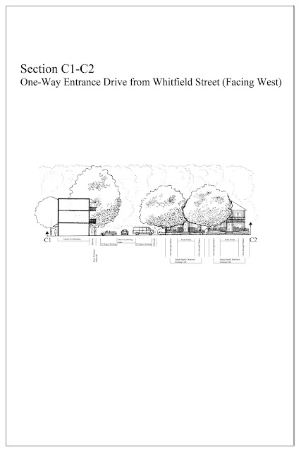
The sections on this post were used to help support the master plan presented on the previous post. The master plan is presented again on this post to show the location of the cut lines.
After reviewing the final sections, I felt as though interesting spaces had been designed throughout the design which should foster a strong sense of community.
After reviewing the final sections, I felt as though interesting spaces had been designed throughout the design which should foster a strong sense of community.
Infill Housing Development Master Plan
As seen here, the three single family detached houses were set back in order to locate the play area in the openspace between the homes. All open greenspace is slightly recessed in order to act as a retention/ swale for stormwater entering the site. The greenspace, located in the courtyard of the single family attached housing area, is recessed 2 feet for the purpose of holding stormwater on site. The waterfeature, located within the mixed use area, is a very cool feature to this design. This feature is meant to resemble the works of Lawrence Halprin. I feel as though this will help create an inviting space that encourages interaction among residents, as well as with people from other communities. Perspectives, details, and sections will be posted on the next few blog entries. These additional drawings should answer any questions you have about the design, but if you have any questions do not hesitate to ask.
Preliminary Section
The section shown here is from the preliminary plan for the infill housing development project.
This north facing section is cut across the single family detached housing units, located on the northern portion of the site. After reviewing this section and the massing model, which will be shown on a later post, I made the decision to set the last three homes along Whitfield Street back in order to bring the play area into the openspace between the homes, instead of being located between the street and the back of the homes.
This north facing section is cut across the single family detached housing units, located on the northern portion of the site. After reviewing this section and the massing model, which will be shown on a later post, I made the decision to set the last three homes along Whitfield Street back in order to bring the play area into the openspace between the homes, instead of being located between the street and the back of the homes.
Infill housing Development Concept Statement
This post should have been before the Preliminary Plan.
A quilt was my inspiration throughout this design process because, in my opinion, a quilt is a very special item symbolizing many different times, traditions, and preferences throughout history. When I think of a quilt, I see many items that have became undesirable, by themselves, over time, but when transformed and united with other undesirable parts, it becomes a special heirloom that sparks conversation among people that see it.
A quilt was my inspiration throughout this design process because, in my opinion, a quilt is a very special item symbolizing many different times, traditions, and preferences throughout history. When I think of a quilt, I see many items that have became undesirable, by themselves, over time, but when transformed and united with other undesirable parts, it becomes a special heirloom that sparks conversation among people that see it.
Preliminary Plan for Infill Housing Development Project
The plan presented here was the starting point for figuring out how I wanted the spaces to come together and create a development which fosters a strong sense of community. The preliminary plan is presented below.
The housing units located on the northern portion of the site are single family detached units. The buildings located on the southwest portion of the site are mixed-use, with retail on the bottom floor and residential units located on the upper floors. The buildings located on the southeast portion of the site are single family attached housing units. The road running west to east across the site is one way, entering from Whitfield Street. There is an alley running north to south allowing for two-way, local traffic. The common green running through the site will also act as a stormwater retention basin, as well as the courtyard located in the single family attached housing area. The next few posts will show the progression from this point to the final design solution.
 |
Inventory and Analysis for Infill Housing Development Project
The following sheets briefly summarize the major information gathered during the inventory and analysis process.
This map illustrates the City of Starkville's zoning classifications within a five, and ten minute walking radius from the site.
This solar study illustrates the angle of the sun during the summer and winter solstice. From this diagram, it was determined that the roof overhangs needed to be at least 3.5 feet in order to protect the home from the hot summer sun.
These wind rose diagrams illustrate the wind direction and intensity for each month of the year. This information helps determine locations of wind screens or features to enhance the breezes.
This diagram illustrates the roads within a five and ten minute walking radius of the site. The roads are classified based on the intensity of use. Because of the school, located north of the site, there is alot of traffic along Scales and Whitfield Streets in the mornings and afternoons. Roads in the development should be carefully places so that they do not add to the traffic congestion during these times of the day.
This map describes the soil conditions on site, as well as the surface water flow across the site.
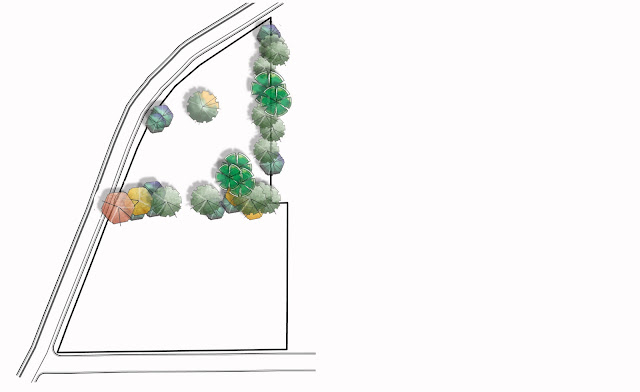
This map illustrates the existing trees on site. Most of the nice trees are showing signs of illness and probably will not survive the stress from development on the site. The healthy trees are by no means specimen quality. All trees removed from site should be harvested so that they can be used as materials during construction.
This is by no means the entire inventory and analysis, but it is a brief overview of the major features existing on and around the site. Based on this information, I had a good starting point for the design process.
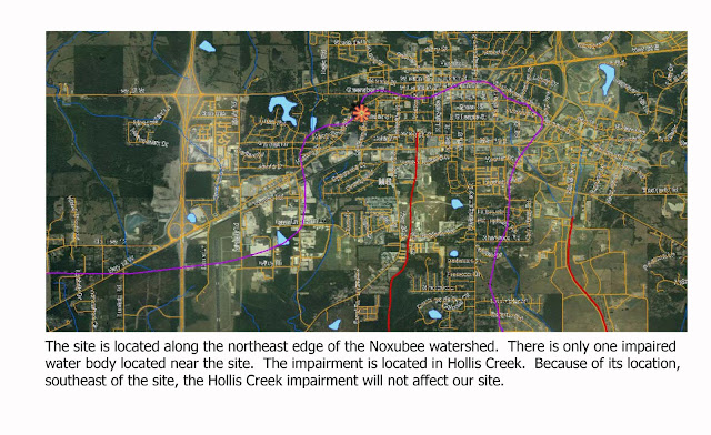 |
| Watershed Map |
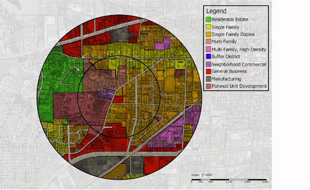 |
| Zoning Map |
 |
| Solar Study |
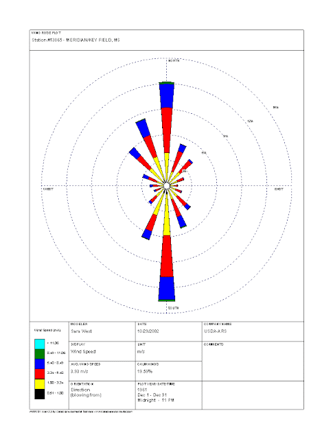 |
| December Wind Rose |
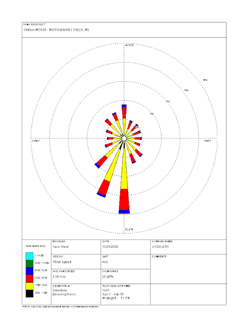 |
| June Wind Rose |
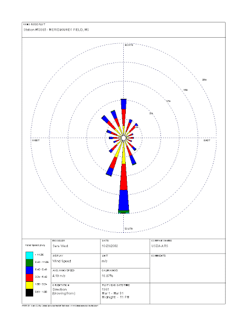 |
| March Wind Rose |
 |
| September Wind Rose |
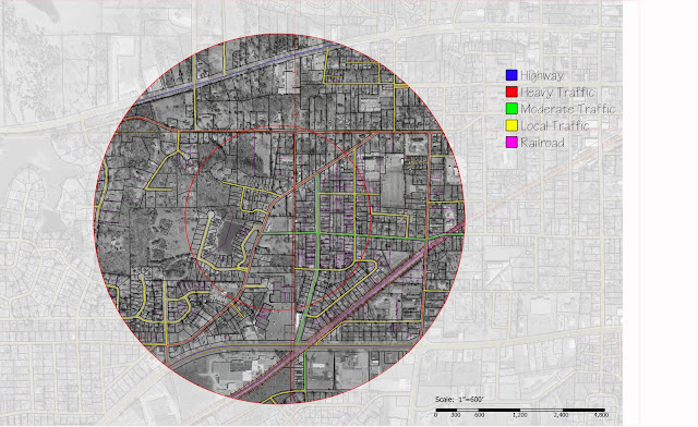 |
| Surrounding Road System |
 |
| Soils, Slope, and Topography Map |
 |
| Existing Vegetation |
This is by no means the entire inventory and analysis, but it is a brief overview of the major features existing on and around the site. Based on this information, I had a good starting point for the design process.
Tuesday, November 30, 2010
Infill housing Development Project- Surrounding Communities
v
This site was very challenging because it is sort of a center point for multiple communities with a wide range of socioeconomic backgrounds. Before beginning the design process, I felt as though it was very important to get a feeling of the overall context of the surrounding communities. The following sheets on this blog posting quickly summarizes the surrounding communities.
Infill housing Development Project
The first project for the Graduate Studio III class was an infill housing development. The site, seen below in a google earth image, is located in Starkville, MS, on the corner of Scales and Whitfield Streets.
Below is the problem statement and a project schedule, which was to be used as a guide throughout the design process.
Below is the problem statement and a project schedule, which was to be used as a guide throughout the design process.
Eyelevel Perspectives for Cohousing Development
This post contains perspectives used to illustrate the different spaces within the design. Two eye-level perspectives can be seen below.
The perspective to the right illustrates the courtyard areas created by the single family detached housing units. I believe these spaces would be good for such amenities as play areas for children. The perspective to the right is a view of the courtyard, created by the single family attached housing units, as seen by a player on the east end of the bocci court.
This perspective is a birds-eye view of the site. The view is from the northeast portion of the community gardens, facing southwest across the development. The main purpose of this drawing is to show the major spaces created by the trees and housing units.
Cohousing Project Detail Plan
For the final phase of the Cohousing Development project, we were asked to fully develop one area of the preliminary plan, seen below.
For the detail plan, I chose to focus on the space created by the single family attached housing units. The Detail Plan can be seen below.
As you can see from the plan above, the Bocce Court was placed in the formal courtyard created by the single family attached housing units. As mentioned earlier the view from the courtyard to the west is terminated by the arbor structure, which shelters the outdoor fireplace and pizza oven area. This area is designed with movable tables and chairs, ideal for lounging or dining. There are pedestrian lights to illuminate the spaces at night. There are two raised seating planters for bocce spectators and people enjoying the outdoors. As the eye moves east, across the central open space, the feeling gets to be less formal, until you reach the community garden area. At noon, during the solstices and equinoxes, the public art sculpture casts a shadow which lands in the middle of the boulders placed in the design. The tree formation in the community garden area represents the star constellation Canis major. This constellation contains the largest star in the sky, Serrius. The Ancient Egyptians said Serrius could be seen in the sky on the night before the summer solstice, which meant the next day the Nile would rise (this process was the backbone of their agriculture). Because of this, the constellation is positioned to be viewed standing on the boulder receiving the summer solstice shadow. The red line connecting the fruit trees is actually an 18" red fiberglass box, which is illuminated at night. The fruit trees themselves have up lighting so that their effect can be noticed at night, at the time people enjoy the stars. I feel as though this design definitely promotes a sense of community within the development. Finally, as mentioned above, the view from the central courtyard to the east is terminated by the greenhouses and ornamental grasses.
Cohousing Project Preliminary Plan
For the preliminary phase of this project, I chose to develop conceptual plan 1. The major deciding factor for choosing plan 1 was the fact that all the single family attached homes addressed the common green, as well as created smaller courtyards extending off the common green. There was still one major problem that remained to be solved, "How do I address Collegeview Street, while also designing with the existing topography on site?"
This plan was very symmetrical, and I was still not pleased that the school buildings isolated the courtyards from each other, as well as the gathering space, which tied all areas of the development together. Another problem I had was that the gathering space, which was to have a fireplace and pizza ovens, was too far away from the community, which would result in it not getting used very often. The preliminary plan I developed, based on these major design issues can be seen below.
As a solution to addressing Collegeview Street, I oriented the southern half of the site with the street and left the northern half unchanged. The entire site was moved south, so that it would be possible to address Collegeview Street. The school buildings were moved to front Collegeview Street. The buildings are meant to be mixed use, with businesses and a bus station on the bottom floors and classrooms on the upper floor.
The outdoor gathering space, with fireplace and pizza ovens was relocated to terminate the view to the west from the single family attached housing courtyard. The greenhouses were relocated to terminate the view of the openspace to the east. I was very pleased at the direction this project was going, but because of time restrictions left in the semester we had to proceed without fully completing this portion of the design.
Conceptual Plan 2
This post will cover the second Conceptual Plan that is developed during the fast paced class exercise. The plan can be seen below.
In this conceptual plan, the single family attached units still formed a formal courtyard. The school buildings were moved to the outer edges to terminate the view to the north and south, while in the formal courtyard. The single family detached units were arranged to be their own separate communities, within the cohousing community. I felt as though this solution did not promote a sense of community as well as conceptual plan 1.
Below are two sections of the plan (the cut lines can be seen on the plan above).
Monday, November 29, 2010
Conceptual Plan 1
The next class period we were asked to choose one of the two functional diagrams we created and develop two conceptual plans, with two sections per plan. This post will cover Conceptual Plan 1, as seen below.
I liked this plan because the single family attached units, seen in light blue, created a formal courtyard. I felt this would help bring residents together, especially with the bocce ball court being in this area. The single family detached units are arranged to create several smaller courtyards, while defining the edges of the common green. The two common houses were placed to terminate the view on either end of the common green. Mixed use buildings were placed along Collegeview Street, but this exceeded the limits set in the project description and would have to be removed before moving into the preliminary plan. The major flaws in this plan are: 1. The community does not address Collegeview Street 2. The two school buildings separate the courtyard created by the single family attached housing, in essence creating two separate courtyards with a central gathering space isolated from both spaces.
The two sections, whose cut lines can be seen in the Conceptual Plan above, can be viewed below.
Functional Diagrams
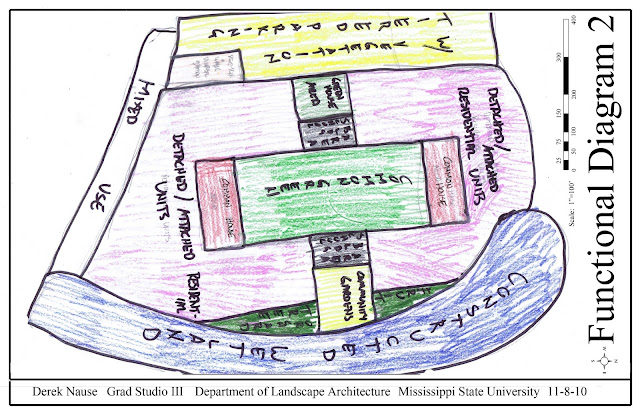
Based on the project description, we were given the task of working out two functional diagrams within the two hour class period. Functional Diagrams one and two can be seen below.
Because of the rapid pace of this assignment, these two diagrams are very similar. I decided to use option 1 as a starting point for the design. I knew this was a very rough diagram to begin with, and the final product would probably stray away from this original vision.
 |
| Cohousing Project Functional Diagram (Option 1) |
 |
| Cohousing Project Functional Diagram (Option 2) |
Cohousing Project Background and Concept Statement
The site is located on Collegeview Street, just west of the Mississippi State University campus. Currently the space is being used as student housing, with some units containing families. A majority of the residents are of various ethnic backgrounds. Currently, the site is being considered for revitalization. The image, as seen from google earth, is below.
Collegeview Street, the major street south of the site, is extremely wide and does not have adequate sidewalks. There are many residences, mainly students of the university, to the west of the site, but the street gets very little pedestrian traffic. Most pedestrians choose to walk a little further in order to walk down University Drive, a much more pleasant street located south of Collegeview Street in an area called the Cotton District. The concept statement used to drive the design can be seen below.
 |
| Google Earth Image of Site. |
 |
| Cohousing Project Concept Statement |
Subscribe to:
Posts (Atom)


